
SENJA: Roadtrip on the SCENIC ROUTE and a hike to HESTEN and SEGLA mountain //EPS.9 EXPEDITION NORTH
12 Video Views·Dec 5, 2022
They call the island Senja two-faced,
green and welcoming on the landward side,
raw, brutal, and stormy on the ocean side.
Join our ride over Norway's second biggest island
and an adventurous hike
to one of its most iconic mountains.
We are on the island Senja now and it's already 8 p.m.
but it's so cool because it's still
like bright daylight outside.
And we are now in the area of midnight sun
and I'm actually so excited to see the midnight sun,
but I don't know if I can really stay awake
because usually I go to bed at like nine or 10.
So we will see if I manage.
Senja Island is like a microcontinent.
It's also known as the fairy tale island
or Norway in miniature
because so many of the nation's highlights
can be seen in this single unique area.
High mountains, fjords, valleys,
colorful villages, beautiful bays.
It's so funny.
My travel partner hates me today
and I think he's actually driving extra slow behind me
because I'm going to make him hike up
this deep mountain called Hesten today.
And from there you have a great view
on the famous Sigla Mountain.
And I can tell you, he is not happy about that at all.
The island of Senja sits northeast of Västerålen,
flanked by the Norwegian Sea, the Malangen Fjord,
the Gesundhed Strait, and the Solberg Fjord.
The outer side of Senja is characterized
by dramatic mountains, an idyllic archipelago,
and sandy beaches, while the inner side
has a gentle landscape of rolling hills and birch forests.
I actually wonder what happens if you meet someone
here in these small tunnels, scary.
We were about to find out soon.
I tell you guys, besides that we just met this big truck
that's blocking our way, these tunnels are not so much fun.
I don't know if you can see that,
but the ground is completely muddy and wet and very slippery.
Really have to be careful here.
The trailhead to Hesten Mountain
starts in the village Fjordgård.
First, it leads over a steep skiing slope,
then through an idyllic low birch woodland,
with wooden footways to avoid your feet getting wet.
The creeks that will cross your way
provide cold and crystal clear water.
Don't forget to try the fresh water
and fill up your drinking bottles for free.
The hike became more steep the closer we got to the top.
So this is the way up that you have to do,
and the goal is to end on this mountain here.
So how much do you hate me for going up here, this mountain?
How much?
Yeah.
Not so much anymore, more this morning, now it's okay.
Because the view is beautiful.
Up over quite some rocks.
The last section to the top of Hesten Mountain,
from where you have the best view on Zegla,
is the hardest part.
You have to climb over some boulders
and up a narrow, steep, rocky path.
And now we realize that we might not have gone
on this little adventure
with the perfect shoes for climbing a mountain.
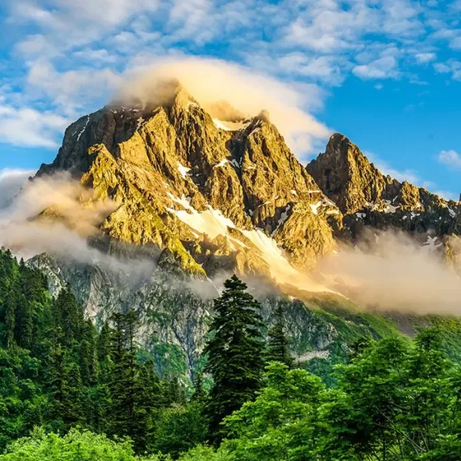
From the top of Hesten Mountain,
you have a breathtaking view
to the nearly vertical cliffs of Zegla.
And from here, you can see why people refer
to the 639-meter-high Zegla Mountain
as the Sail of Senja Island.
Its north cliff is 300 meters vertical rock face,
and the west side drops vertically 639 meters
down to Mefjorden.
The top of Hesten offers, as well,
a 360-degrees panoramic view in all other directions.
Nearly 600 meters below,
you can look over the bright blue waters
of Oifjorden and Mefjorden.
On video, you always see it, but this is quite a steep.
What I tell you, going down is much worse
than going up with our kind of shoes,
because we have these shitty sneakers
with basically no profile.
That's how, here, you go down,
if you have the wrong shoes,
holding onto those little trees you see here.
You think that's gonna hold you?
Who hikes can, as well, handle
some delicious fish and chips afterwards.
I have to admit, before we came here to Senja,
I was a bit anxious because I wondered
if it can keep up with the beauty of Lofoten Island,
but it definitely can.
I love this place so much
because it's much less touristic
and it feels much more remote than Lofoten,
and still, I mean, look at this.
The landscape is stunning.
Our ride back to our accommodation
took us again over Senja's scenic route
to the Bergsboten mountain range,
and it offered amazing views over Stormsboten.
My travel partner and I, by the way, for once agreed.
If we would choose a place to stay
and explore a bit longer,
we would choose Senja over the famous Lofoten Island
because we fell in love with this place in Norway.
So good news is that Senja is really absolutely stunning.
Bad news is that when we were hiking,
I got bitten by a lot of flies on my ankle
and my foot now feels super swollen.
Actually, I can barely feel my foot anymore.
I don't know what it is,
but it really doesn't feel that good.
Overnight, we stayed close to Hamm i Senja.
Hamm means port,
and a cluster of islets provide a sheltered safe haven.
Hamm i Senja is an old trading post for nickel
and couldn't be more dramatically situated.
The Sugarloaf Mountain straight south,
the 98 islands of the Bergsfjord to the north,
and the endless Atlantic to the west.
My swollen foot started to hurt badly during the night
and kept me awake.
So I, for the first time in my life,
could witness the famous midnight sun.
This footage was taken between 12 p.m. and 2 a.m.
So today is day 14 of our journey,
and it's actually the second day
that we are starting without pouring rain from the start,
and today is gonna be a sunny day.
So that means the first day
of putting the pants inside the boots.
Yes, we finally were able to escape the rain.
The next episode will bring us closer to North Cape
and take us on a beautiful ride over the Lyngen Alps.
If you want to meet some reindeers
and find out why my foot was still swollen
and why we had to buy three liters of oil,
subscribe my channel and tune in next Thursday.
And leave a thumbs up and comment
if you like our hike to Senja.